LiDAR sensors vs AI video analytics for people counting
From depth maps to digital twins - a clear comparison of two technologies that are reshaping how we understand physical spaces.

The boundary between the physical and digital world is becoming increasingly blurred. In this landscape, two technologies stand out: LiDAR sensors and computer vision - especially when combined with AI. Both share a common goal: transforming how we perceive and optimize spaces and the people who move through them.
Ultra-precise depth maps: LiDAR
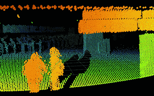
Imagine a beam of light moving at a frantic pace, measuring distances with unmatched precision and generating a hyper-detailed map of spaces and the people in them. That is the essence of LiDAR.
This technology, originally developed for climate research and cartography, has been adapted for people counting. But its precision comes at a price: devices range from $1,000 to $10,000 each, which can limit implementation in many retail and commercial contexts.
The eye of artificial intelligence: computer vision
On the other side: computer vision with AI - an evolution of traditional cameras. With costs far lower ($50 to $500 per camera), this technology can see, understand, and analyze images and video in real time. It does not just count people; it understands their behavior and interactions.
In terms of development speed, the gap is stark. Computer vision AI generates approximately 30 internationally recognized research papers per year introducing new techniques. LiDAR AI produces around 3. The pace of improvement is not close.
30 vs 3
New AI techniques per year: computer vision vs LiDAR

Scalability and cost: where vision wins decisively
The comparison is not just technical - it is economic. A single $1,000 PC can analyze up to 50 cameras simultaneously. The cost to install 50 LiDAR sensors for the same coverage is not comparable.
Security cameras are also typically already installed in commercial spaces, eliminating any need for new infrastructure, cabling, or hardware investment.
Computer vision is 10 to 100× more cost-effective than LiDAR
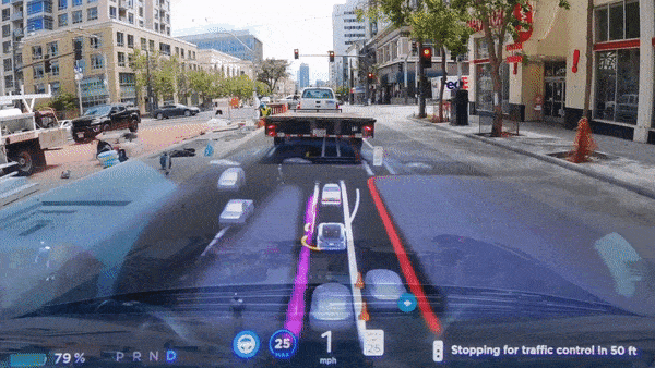
What the autonomous driving industry reveals
The autonomous driving sector offers a clear illustration of this debate. Tesla chose a camera-only computer vision approach for its FSD (Full Self-Driving) system, betting on economic scalability. Other operators - such as Waymo - combine LiDAR with cameras to maximize precision in their commercial robotaxi services.
There is no universal winner. Each approach reflects different priorities around cost, precision, and context. Where LiDAR remains unmatched is in applications like topography, archaeology, and precision mapping - fields where its depth accuracy cannot be replicated.
For the commercial spaces sector, the economic argument for camera-based vision is decisive at scale.
The future: AI-powered digital twins
One of the most powerful applications of computer vision with AI is the creation of digital twins: real-time virtual replicas of physical spaces. KSI Vision, for example, generates live digital twins of stores, shopping centers, airports, and passenger terminals - enabling continuous monitoring of people flow, zone performance, queues, and operational conditions.
LiDAR and computer vision are not necessarily rivals. In some specialized contexts, they are complementary. But for cost-sensitive, large-scale commercial deployment, camera-based AI is the clear path forward - and it improves at 10 times the pace.
See what KSI Vision can do with your existing cameras
Turn existing security cameras into real-time analytics - no new hardware required.
Request my demoRelated articles

Computer Vision vs People Counting Sensors: Which Is Better?

About KSI Vision: the team building the intelligence layer for physical spaces
